


Lexington’s Comprehensive Plan
What is the Comprehensive Plan?
Lexington’s Comprehensive Plan (Comp Plan) is the 20-year plan that guides how land is used in our community. It sets priorities for how neighborhoods are developed, what types of jobs we have in our community, how our transportation network is laid out, what efforts we take to steward the environment, and how we grow.
The Comp Plan (currently called Imagine Lexington 2045) is updated every five years and sets growth priorities for the next twenty years. It is required by state law.
The Comp Plan is created by Lexington’s Division of Planning, which falls under the purview of the Mayor, but it must be adopted by the Planning Commission and the Council. The Division of Planning and the Planning Commission are responsible for following through on the goals in the plan and executing the strategies it sets.
📮 Recent Updates:
Lexington's 2045 Comprehensive Plan
Lexington’s Goals & Objectives were recently adopted. You can read the updates during this process above.
2045 Comprehensive Plan’s Goals & Objectives
The Goals and Objectives are where the Comprehensive Plan gets specific - they have direct policy implications for Lexington’s environment, housing, transportation, jobs, and more. The first big thing to understand about these new goals and objectives is how they differ from those written five years ago.
Here are some of the key changes in the 2045 Goals and Objectives:
There is lots of new language about racial equity.
There is a more nuanced focus on the environment.
There are more policies on stormwater and sanitary sewer infrastructure.
There will be a new plan to manage the Urban Service Boundary.
So, what do you think of these changes? Do they reflect the input you gave in On the Table? Do they speak to your vision for the future of Lexington? You can read more about the changes here.
A Comprehensive Plan, or Comp Plan, is a document that city governments around the country use to lay out how a city or county should grow over an extended period of time (20 years in Lexington’s case). It is a way of planning for the long term goals of a city, and is designed to be created and used by the entire community - including residents, developers, business owners, government employees, and more!
In Lexington, the Comprehensive Plan (or Comp Plan) is updated every 5 years and published by the Planning Department, after review and approval by City Council and the Planning Commission. Lexington’s last Comp Plan came out in 2018 and is called Imagine Lexington. Imagine Lexington was a pretty big deal in the world of Lexington planning - it has more community engagement, a new structure, different branding, and a lot of substantial changes from previous Comp Plans. The next Comp Plan will be released in 2023, and will continue the modernizations of Imagine Lexington.
Why do we have a Comp Plan?
There are a lot of reasons to have a Comp Plan. One of the biggest ones is that Kentucky State Law actually requires it or a similar document for communities that regulate land use. Comp Plans are also a big part of how cities make decision about zoning changes (changing what kind of building can be constructed in a certain place) and new developments. Regulating these processes through a 20-year document like the Comp Plan helps make sure the polices are thinking about the future, accessible to the community, and all organized in once place.
What is a Comprehensive Plan?
How to read the Comprehensive Plan
The majority of the 2045 Comp Plan is organized by Five Major Themes. These themes are how the goals and objectives (AKA the specific desired outcomes) of the plan are categorized, so it’s important to understand how to use them.
The Comp Plan is structured around five Themes: Neighborhoods, Environment, Jobs & Prosperity, Community, and Urban/Rural Balance. Near the beginning of the Comp Plan, there is a section called Goals & Objectives, which is mandated by state law, and are adopted by Council. It contains broad goals for each theme and objectives or steps to achieving each goal. Following Goals & Objectives, there are detailed sections on each theme.
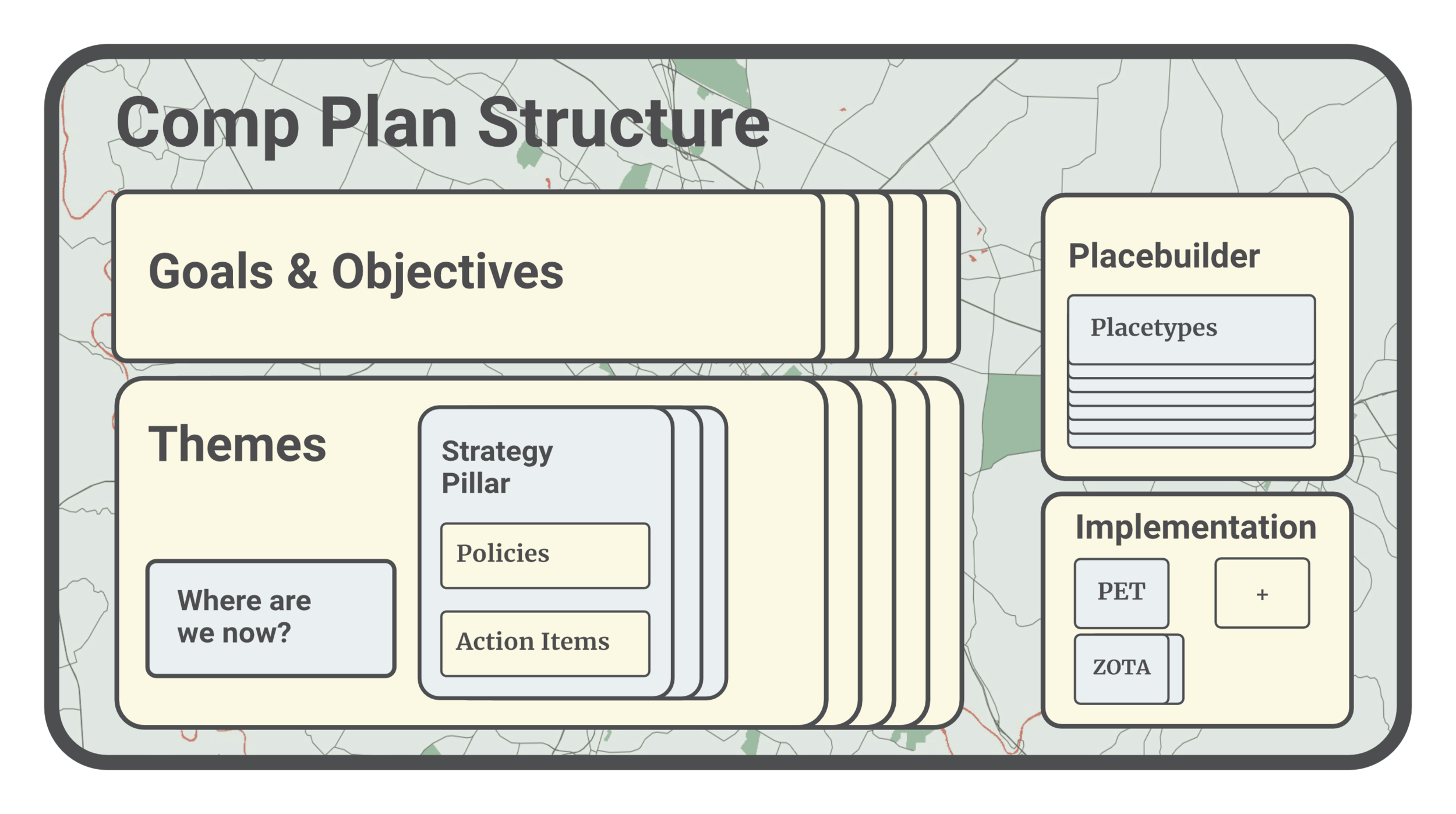
One way to think about it is to imagine the Comp Plan as a giant tree. If the plan is a tree, the themes are its five biggest limbs. Each branch has smaller branches (the goals), and those branches have their own twigs (the objectives). Beyond the goals and objectives, themes also contain other important information, including a description of where we are now and a strategy pillar with policies and action items for implementation.
If you want to make an argument using the Comp Plan, you should be able to draw a clear line between whatever outcome you want and the objectives, goals, and themes that your outcome satisfies. Each theme, and some of the specific objectives they contain, are listed below.
-
Diversify housing, recreation, and transportation options
Create inviting neighborhood focal points
Make streets walkable, safe, and efficient
Promote building up Lexington’s interior areas, not out into the rural communities
Work toward better serving populations with particular challenges, such as renters and seniors
-
Protect floodplains and Special Natural Protection Areas
Promote agritourism & ecotourism
Build more environmentally friendly buildings
Encourage alternative methods of commuting
Restore green spaces by planting trees, repairing our sewer system, improving our air quality, and taking care of trails and green spaces
-
Inventory and analyze how land is currently used
Update Lexington’s zoning to optimize land use and for home-based jobs
Promote development while minimizing displacement in opportunity zones
Create job opportunities for area students, revise ordinances to reduce vacancy rates for business zones
Develop a plan for the Coldstream business park
-
Build well-connected subdivisions that are close to amenities like schools and markets
Design streets that are safe and easily accessible to pedestrians and cyclists
Encourage density with zone changes that allow for varied housing types and mixed uses
Promote development along main roadwaysItem description
-
Update the zoning ordinance to reflect the Comprehensive Plan’s recommendations
Establish a new process for long-term land-use decisions involving the Urban Services Boundary
Create public outreach and education programs for the Comprehensive Plan
Inventory and create programs for restoration and preservation of historic or culturally significant assets
What are some of the topics that the plan impacts?
The themes of the comp plan cover A LOT of different topics. We have listed some of them out below. If you want to get into more detail, you can check out the Imagine Lexington Website.
Theme 1: Growing Successful Neighborhoods
Housing
Infill and Redevelopment, the process of creating new housing/businesses by renovating or replacing current buildings or on vacant lots, instead of developing on new land
Neighborhood Design
Community Facilities
Theme 2: Protecting the Environment
Fayette County’s carbon footprint
Conserving natural resources
Theme 3: Creating Jobs and Prosperity
Attracting quality jobs to Lexington
Building up local businesses and job opportunities
Increasing land available for economic developments
Theme 4: Improving a Desirable Community
Transportation
Public safety and social services
Education
Cultural & historic preservation
Theme 5: Urban and Rural Balance
The Urban Services Boundary
Agricultural and natural land in Fayette County
New Developments (housing + businesses)
How is Lexington impacting the Comprehensive Plan?
The implementation of the Comp Plan can be seen all across the city in various stages of their life cycle. Some are enacted legislative changes like the Floor-to-Area Ratio Zoning Ordinance Text Amendment (ZOTA), while others, like the city’s proposed ADU Ordinance, have yet to be finalized. Increased greenspace, wider bike lanes, new developments - all of these are part of the implementation of city’s Comp Plan.
But there are other types of implementation that are easier to grasp - two of which are the Placebuilder and the Public Engagement Toolkit, detailed below.
The Placebuilder
The 2013 Comp Plan was released without a specific land use map for the first time ever, in an attempt to make the plan more flexible and open to innovation. However, many people worried that this made the Comp Plan too ambiguous, so in 2018, The Placebuilder was created. The Placebuilder is a new system for deciding what types of developments can be built where using categories called Placetypes.
Each Placetype has its own recommendations for development types and its own criteria for how those development types might be met based on the five major themes of the Comp Plan. Placetypes are designed to be more flexible than a land-use map, allowing a developer or resident to make a case for why a certain building would meet enough of the criteria to be suitable, or why certain suggestions shouldn’t apply to a given structure.

Public Engagement Toolkit
Resident engagement is one of the most difficult aspects of development. Miscommunication and a lack of understanding of how best to engage with neighborhoods cause frustration and mistrust throughout the development process.
The Public Engagement Toolkit (PET) addresses these issues for both developers and residents and provides guidance for both in-person and digital meetings.
For Developers, the PET provides a set of best practices for how to engage with residents in a productive way and sets core recommended principles for development, including new methods for notifying residents of new development. It also includes a set of guidelines for holding community meetings about zone changes, including bringing in a third-party facilitator, taking into account differing abilities, and hiring translators where needed.
For residents, the PET provides a way for residents to better understand the development process and know where to find information about proposed developments. It also gives more validity to the concerns of residents about being in the dark during zone changes.
Other Implementation Steps
Open Space ZOTA
More coming soon.
Imagine New Circle Road
More coming soon.
Imagine Nicholasville Road
A public engagement process and study on identifying strategies for redevelopment along Nicholasville Road, including traffic flow changes and the introduction more housing and a mix of land uses along the corridor.
Sidewalk ZOTA
A change to how city builds sidewalks that expands the requirements from 4’ to 5’ width, to make it easier for two people to walk side-by-side.
Affordable Housing Parking Requirements
A change to regulations, requiring Affordable Housing developments only have 1 parking space per dwelling unit, requiring less infrastructure for its development.